There have been many highlights during our NZ stay, but the 8 day, alpine hike in The Nelson Lakes National Park was a series of magic moments strung together with sore muscles, team-work, a couple of blisters, and a sparkling sense of accomplishment. The initial idea was all Kai’s. His 13th birthday wish was for an epic hike….and an epic hike it was!
We met a family from Nelson on a beach in Fiji. We also bumped into them at the Womad music festival. When we told them about our planned hike they offered us their spare car to get to The Nelson Lakes National Park, about 88km from Nelson itself. You beauty! Thanks!!!
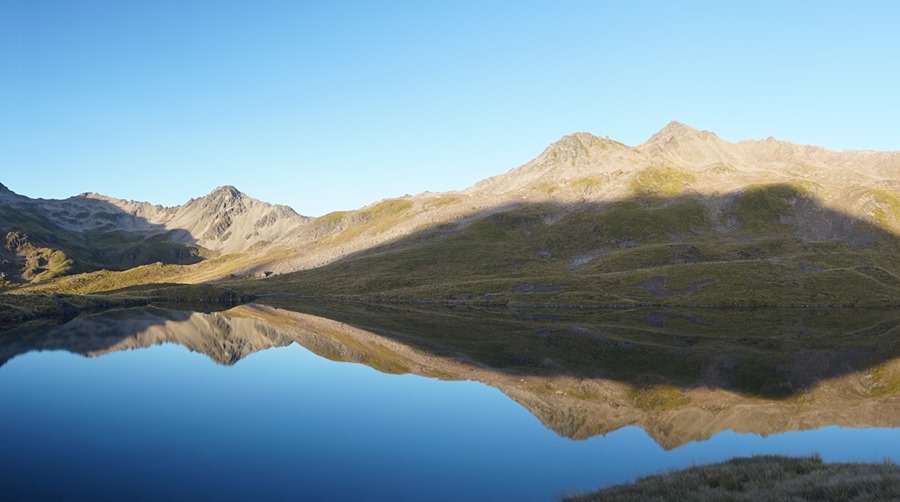
We left Tika nestled in the marina and drove to the Mt Roberts Carpark (880m above sea level) to start our 8 day adventure. Between us we carried 10 kilos of food, a stove, bowls, sporks, a knife, mugs, sleeping bags, a medical kit, water, gortex jackets and overpants, spare clothes, coffee, chocolate and a pack of cards! Our back packs were HEAVY! We had upgraded Kai’s pack to a new, 50 litre Macpac and Jaiya inherited his old 35L Osprey. We were all carrying our individual maximum capacity. Day 1 was a short, 2.5hr doddle up to Bushline Hut (1280m.)


Above left: 4 fresh hikers! at the start- Mt Roberts carpark. Above right; great views on our first night at Bushline hut.


Above right; from the porch of Bushline hut; where even the toilets (above left) had a view.
The Nelson Lakes National Park covers 1020 sq km and is centered around two large lakes- Ratoriti and Rotorua. Our plan was to do the Travers-Sabine circuit along Roberts Ridge, down over Mt Cedric with a side trip up to Blue Lake.

Above; Kai mapped out a profile of our route
At 4.30pm, Bushline hut was deserted and we were hopeful that we may have it all to ourselves. We lit the fire and started to make ourselves at home. We had just convinced ourselves that dusk was too set in for hut-mates to appear, when we see a girl emerge over the hill and follow the winding path towards us. She seemed young and we asked her if she was alone “no, there’s 7 of us…and our teacher”
And so our dreams of a peaceful first evening out were shattered by the all night giggles and entertaining conversations of 7x 13-15yr olds out on a school camp ![]()


The following morning we ascended Paddy’s track to Pinchgut track and Roberts Ridge.


We could look down to St Anaurd, the small town on the edge of Lake Rotuiti.


Roberts Ridge was where the magic really began. After popping up above the tree line we followed the route through sections of sharp, rocky boulder fields to Julius Summit at 1794m. The ridge was very exposed and beautifully rugged and we had jagged a bright, clear, sunny day. I would not want to attempt Roberts Ridge in high winds and poor visibility. Steep slopes of rock and scree on the spur in between peaks up to 1877m meant sections of scrambling along the side of drop-offs with unstable underfoot rubble.


It was a 6 hr, 10.5 km hike from Bushline hut along Roberts Ridge to Angelus hut.


Above; A Falcon landed on the rocks close by and watched us curiously as we trekked between the fluorescent orange route poles. Gorgeous.


Above; traversing the ridge


Arriving at Angelus Basin. You can see the hut way down by the lake. At this point I was tired and I remember thinking that it still looked SO far away! Day 2 and my legs are still adjusting to land lubbing and easing into the hike..


Above; Looking down on Lake Angelus and Angelus hut from Mt Roberts Ridge

Above; Angelus hut


There is something special about alpine flowers. They survive in the most rugged of climates and their beauty seems to be magnified by their harsh surroundings. Above right; gentian violets.
Above left; Angelus hut at 1650m. This is the only hut on the entire trek that we had to book in advance and it was full the night we stayed. There are many routes to Angelus and all of them are decent walks. The appreciation of the warm, dry, modern hut with it’s views over the lake, pot belly stove and sun-ladened deck was palatable amongst the 30-40 trampers that rested aching muscles in this wonderful alpine haven.

I’d like to be able to say that having a 9 year old with us slowed us down, but in truth, I was the slowest member of our little expedition! When Kai first showed me the profile of his dream hike, I was 100% convinced that I wouldn’t be able to pull it off and I had visions of being helicoptered out leaving Russ and the kids to carry on with out me. Although we didn’t meet any other families hiking with children we did meet many, many serious walkers on this tramp. We like to think of ourselves as a pretty adventurous family but most of the people out there exploring the back country had us feeling a tad inadequate!
We met locals who did Roberts ridge as a day walk and, after a leisurely lunch at Angelus hut, took off back along the ridge that would have them descending back to the carpark at sunset. I was so happy to arrive at the hut after 6 hours of traversing the ridge that I simply could not fathom doing the return journey in the same day! We were passed by young hikers who literally skipped around us and disappeared ahead with impressive speed. One Canadian backpacker carried his ukulele at the top of his pack and had pretty much summited every peak (on and off trail) in the park. We met two 60 yr old kiwi women out for a weekend and planning two 11-12hr days that involved conquering both Waiau Pass (1870m) and Thompson Pass (1796m; a no-trail, unmarked route)
We met a crazy number of people walking the TeAraroa trail (‘affectionately called ‘The Way,’) a 5 month, 3,000km tramp across the entire length of New Zealand! Some trampers had walked (or had ambitions to walk) the Pacific Crest Trail and/or the Appalachian Trail (both run north to south across the entire length of the United States)
Long term hikers are a breed of their own and are fit, strong and tenacious creatures. Sadists maybe. But kindred spirits who share our love of the great outdoors and independent travel.
Of course my ocean-going legs did get stronger after a few days- by the end of the hike I had the feeling that I could cheerfully keep going and I could certainly get a sense of the addiction to the highs and lows of walking for entire days, weeks, and for some, months…..


Day 3 was my absolute most favorite, best-ever day of them all. After a climb up from the lake, the route of snow poles and cairns guided us up and down a moonscape of rubble with steep sided glacial dips and peaks. After 2-3 hours we came to the top of the world…I’m not going to say too much here- I will let the pictures say it for me ![]()


Above left; Giant Vegetable Sheep- an alpine plant that reminded me of intricately wrapped whorls of felt. It was soft and lush and each delicate, furry layer had a new shade of subtle, pastel green.


After crossing the moraine fields there were a couple of peaks that the kids described as ‘airy.’ Actually, I wasn’t quite sure if they were saying ‘airy,’ ‘hairy’ or ‘scary’ but it doesn’t really matter because these sections were all three! It’s not that the path was particularly technical. At times it required a scrabble or climb using both hands (which was physically challenging when carrying a full pack) but generally the path was well worn and solid underfoot. The intimidating parts were the steep edges, the type that leave you with thoughts of slipping into an abyss with no possible way of breaking your fall. We kept the kids close, although in truth, with their cat like agility and low center of gravity, they were probably a lot safer than most adults.


As we approached the rounded profile of Mt Cedric’s ridge (1532m) we were greeted with the most ethereal landscape; swirling clouds and 360 degrees of ranges and peaks- some with clinging patches of snow. It was a bewitching sight.


I love this shot. Oh what a feeling!


Airy, hairy and scary…..


Above; spot the hiker…


We started our descent through tall tussock and steep, uneven ground. We could see the tree line way down below! Eventually we stopped for lunch to enjoy the last of the vast openness before plunging head first into the 1400m, steep, heavily wooded slide down to Sabine hut.


I find descents much harder than ascents and my right knee doesn’t like it much either….The sharp incline of the trail was made super slippery by leaf matter and moist soil. I was slow and super careful but managed to keep my falls to a minimum. Russ and the kids raced ahead counting their slips and comparing injuries all the way. Russ won the competition with this (top center) battered left buttock! The trail went on and on and we were very grateful to arrive at Sabine hut- despite the fact that it was our least favourite DOC hut- full of sandflies and a bit grotty and unkept. Still, it had a fabulous view of Lake Rotorua and the fire was luxe.

Day 4, surprisingly was a super hard day! I say surprisingly because it was scheduled to be a long but relatively easy one- 5 hours to West Sabine hut according to the DOC times. The map showed a flat trail, and we figured we could skip all the way and then add on a 3 hour ascent up to Blue Lake hut (1190m) Expectations are a dangerous thing. My morale started to deflate after the first hour when we reached a bridge that was marked to be just 30 minutes from the hut. Really? we may be a tad slower than DOC times but double? That 5 hours took us 7 and the path was littered with fallen logs, detours and debris. Either the last few days had caught up with us or the trail had sustained damage in recent storms and the DOC times had not been adjusted to allow for the extra care required. We walked 13km, ascended 290m and descended 60m. We were all a little devastated that we didn’t make it to Blue Lake but we adjusted our plans and scheduled a (big backpack free!) day trip up and back the following day…


Above left; West Sabine hut.
On day 5 we were light and fast for the 3 hr climb up to Blue Lake- reputed to be the clearest water in the world.


Just about every afternoon, Russ and I would dive into a mountain stream or lake to watch off the grime from the day- all were cold but Blue Lake had a special edge of freezing. It was so cold it was painful!


While Jaiya and I happily read kindles and soaked up the sun by Blue lake, Russ and Kai popped up the Waiau Pass trail to get a view of both Blue Lake and Lake Constance…


We scooted back down to West Sabine and had the hut to ourselves for a night by the fire… We woke in the wee hours of day 6 and walked for 2 hours pre-dawn to get a head start on a big day- crossing Travers pass. It was pretty exciting clambering up the West Sabine Valley under the beam of head torches!


Above left; after 2 hours on the trail daylight emerged through the tree canopy and we are able to turn our head torches off. We crossed the deep chasm of the East Sabine River and began the steep climb, zigzagging up from the valley floor. Eventually we again emerged from the tree line and stopped for a break before continuing to Travers Saddle. We were rewarded for our efforts with stunning, panoramic scenery…


Travers Pass requires ice axe and crampons in the winter and well into the spring months. Even at this time, towards the end of an NZ summer, large patches of snow cling to the hollows and valleys close to the many peaks in the range.


After crossing Travers Saddle we dropped down the other side, descended into a boulder strewn valley of alpine shrubs and landed at Upper Travers hut by 2pm in the afternoon!

Upper Travers hut- a welcome sight after a big day on the trail! a 4am start, 7.2km that included a 947m ascent and a 460m descent. The hut sat next to the Travers river beneath the towering, intimidating face of Mt Travers.
Day 7 was the first day we wore our gortex jackets but the drizzle didn’t last and we continued our extreme, blessed luck with weather. We covered extensive terrain of tussock-covered flats and stunted forest as we plummeted towards the Cupola Creek gorge. Travers falls was a good excuse for a water break and rest…


Looming mountains still towered above as we followed the valley down, stopping for a leisurely lunch at John Tait hut. The narrow valley opened up to forested terraces and grassy river flats as we approached Lakehead hut for our last night on the trail. Today we descended 712m and walked 22.3km. Our packs were getting lighter everyday as the food disappeared!


The swing bridge that spans the river just before Lakehead hut is an experience in itself. A one person bridge, it is narrow and sways quite radically.
We had Lakehead hut all to ourselves and our packs exploded; scattering gear from one end of the cabin to the other. We made ourselves at home and played cards by the warmth of the fire for one last night on the trail.
Day 8 included a cold-footed river crossing and a short stop at Whiskey falls…

We didn’t invest in expensive hiking boots for the kids, but we did pay obscene amounts for some quick dry gortex socks. Worth every cent!


Above and below; Whiskey falls. One great thing about tramping in NZ is that water is plentiful and you really don’t need to carry very much on your back. We had mugs hanging off our straps and stopped for drinks in the many rivers, streams and falls we passed along the way…


Above right; an iconic fly agaric mushroom. And yes, they do have hallucinogenic properties!
Below; my feet hurt when I hike. Not my legs, not my back (well ok, my back does hurt a little bit) but MY FEET! Maybe I haven’t yet found the perfect boots. Bliss for me was taking my boots off; and I did this at every break and every lunch stop. Anytime I could. Pure heaven!


Above right; a mid-morning break at Coldwater hut that is perched right on the lakes edge.
We traipsed along the lake shore and then through dense manuka and kanuka trees then we headed back up to join the path from bushline hut where we retraced our steps back to the Mt Roberts Carpark. It was joy being able to jump into our borrowed car. Incredibly, just as we started driving back down towards St Anaud, the heavens opened and a hefty drizzle set in. Inside, 4 whiffy but contented hikers could be seen grinning out between the grimy swish of the wind screen wipers…
Below; a quick flick of Kai’s epic birthday hike!


Above left; Kai’s detail of our walk (in red) and our drive (in green) and if you look closely, he even has our sail covered (in blue)![]()
Below left; He also detailed our ascends descents and total km walked for each day of the walk
Below right; happy campers with much deserved ice creams


Next post; Nelson, The Marlborough Sounds, crossing Cooks Strait and a passage back to Auckland!
This entry was posted in The Sail.
Fantastic read and photos, wish we could have joined you xxxx
me too Jane